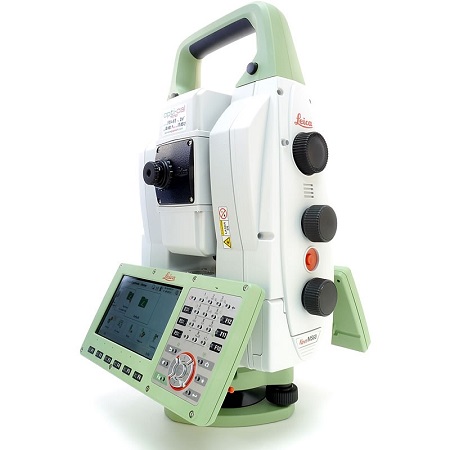


Leica Nova MS60 MultiStation
$17.200 Original price was: $17.200.$14.400Current price is: $14.400.
The ultimate all-rounder, combining total station functionality with 3D laser scanning, GNSS connectivity and digital imaging
Description
The new version of Leica Nova MS60, the world’s first MultiStation, enables you to perform all surveying tasks with one instrument. It brings sensor fusion to the next level by combining:
Highest-end total station capabilities
3D laser scanning, enabling you to scan up to 30’000 points per second
GNSS connectivity
Digital imaging
MultiStation 1″ with automatic recognition, Captivate, Imaging, and scanner
First MultiStation in the world, the Leica Nova MS60 combines all available measuring technologies in one superior instrument: continuous adaptation to the surroundings, laser scanning, imaging, long-range measuring without the need for a prism, high accuracy and piezoelectric motorization technology. The Leica Nova MS60 multistation comes with the Captivate software and includes the new self-learning ATR+ technology, providing the most advanced lock-on capability in the world.
The MS60 comes with Leica Captivate, an onboard software with easy-to-use apps that cover all your surveying tasks. To make your work even more productive, you can benefit from the MS60’s Dynamic Lock feature as well as the newly added, revolutionary setup assistant feature, AutoHeight – which helps you set up even faster and more accurately with the simple press of a button.
When to use the Leica Nova MS60:
– Surfaces and volumes in construction and mining: spoil heaps and stockpiles, DTM creation and checking surfaces, material thickness, blast faces, and ground levels
– Analysis of complex structures and objects within plant, marine and utility projects: dimensional control, as-built, and record-keeping
– Measuring buildings and structures: bridge condition/clearance analysis, BIM and as-built
– Façade, elevations and heritage work: the creation of traditional façade deliverables, 3D models and photographic documentation
– Traditional topographic surveys for surveying and mapping: the creation of traditional deliverables like 2D maps or 3D models
– Monitoring measurement and analysis of ground and structures: real-time or periodic measurement of bridges, dams, buildings, and earth, ice and snow
Highest-end total station
Highly accurate angle and distance measurements, long-lasting design, and easy-to-use apps are key elements of modern total stations, fully embodied in the MS60. With improved automation functionalities using ATRplus, the MultiStation increases your efficiency, even under challenging environmental conditions.
3D laser scanning
Scan with up to 30.000 points per second (Hz): complete your scans fast and get dense scanning grids. The MS60 features optimized scanning paths, now including zenith scans, allowing you to significantly reduce the total scanning time.
GNSS connectivity
GNSS is fully integrated into the workflow and the data structure, enabling direct georeferencing. SmartStation and SmartPole setups increase your flexibility in the field.
Digital Imaging
Enhanced digital imaging technology, including an overview and a 30x magnifying telescope camera, enables accurate image assisted surveying both at the instrument and remotely – while also including extended image documentation.
Recent View
Olympus EPOCH 1000i Flaw Detector
Faro Freestyle 2 Handheld Scanner
Leica P30 3D Laser Scanner
Leica ScanStation P40 3D Scanner
Leica iCON iGD3 – 3D System
Topcon X-53i LPS Excavator Positioning System
Spectra Precision DG813 Pipe Laser w/ Spot Finder
Related Products
FARO Laser Scanner Focus3D X 330: The Perfect Instrument for 3D Documentation and Land Surveying

FARO Focus 3D X330 Laser Scanner
This Creaform Revscan 3D has been calibrated by Creaform authorize, fully functional and set up ready to working condition.

Creaform Handyscan Revscan 3D Scanner
Creaform HandySCAN BLACK is a high performance, metrology grade optical laser 3D scanner, the Accuracy of 0.035 mm (0.0014 in) and a scanning speed of 800,000 measurements per second

Creaform HandySCAN BLACK 3D Scanner
Faro Focus S150 Laser Scanner, enables fast, Range 0.6 – 150m, HDR Photo Recording 2x/3x/5x, Measurement Speed up to 976,000 points/second, Ranging Error ± 1mm

FARO Focus S150 Laser Scanner
Creaform HandySCAN 307 3D handheld 3d scanner, The Accuracy Up to 0.040 mm (0.0016 in), Light Source 7 red laser crosses

Creaform HandySCAN 307 3D Scanner
Our store info

AMG Tower. Jl. Dukuh Menanggal No.1 A, Dukuh Menanggal, Kec. Gayungan, Kota SBY, Jawa Timur 60234 Branch Office :
13 Joo Koon Cres, Singapura 629021
Branch Office : +6552 4125
Customer care
Statistic
© 2022 Marine Surveying Supplies. All Rights Reserved.


Reviews
There are no reviews yet.